The Site
The Design Comet, a small committee, formed last summer to move the design process forward with the hopes of starting construction this coming summer, 2005. The first things the comet did was to take a look at what had been done. Many things had been decided, including well location, kitchen and bathhouse locations and the construction of a road to the well site. After collecting a lot of information about our water system, sun patterns, sound and neighbors, the Design Comet decided to reconsider the site plan and hold off on any further construction until this spring.
To begin with, we (the comet) began looking at the overall site, the allowed development area, and the clearing that had been done to date, with an eye toward siting the building to take advantage of sun, slope and any aesthetic features on the land.

This sun study shows how sun plays on the land throughout the year. This study showed that because of tree heights that any buildings placed along the western side of the meadow or any cleared land would be in shadow a good part of the day, even in mid-summer. This suggested moving the buildings to the eastern side of the land where they could receive full sun most of the day. Three schemes were developed start the design process.

The first shows the site as it is, with nothing done to it. A meadow has been cleared and a road cut in. There are no buildings on the site. This do nothing option was really not an option since our permit to be on the land requires us to make certain improvements, such as the water system.

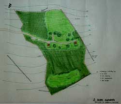
The second shows two acres cleared and the buildings as permitted. The two buildings (brown squares) shown are the permitted kitchen and bathhouse. The kitchen was permitted to be 576 square feet and the bathhouse 400 square feet.

The third plan shows five acres cleared and the buildings relocated to above the road and to the east of the meadow. This arrangement came about as a result of discussions on the land, looking at sight lines, sun, accessibility and construction issues and was ultimately chosen as the route to pursue for further development.


0 Comments:
Post a Comment
<< Home